Showing posts with label Yucatán. Show all posts

Tuesday, January 4, 2011

Happy New Year

Before too much time passes, I'd like to comment on the fireworks presentations in Mérida on New Year's Eve.  We stayed home, mostly because of my lingering leg injury. With a slow hobble and Pablo's assistance we made it up to the rooftop around midnight.  There were so many fireworks exploding the whole scene was reminiscent of NYE in Hawaii or a night out in Iraq. The streets and air were so full of smoke, visibility was about ten feet. The explosive loud noise occasionally disturbed my ear drums. 

We could see big colorful globes emanating from churches and other organized exhibits from our vantage point.  The  neighbors all around us had bottle rockets and m80s or cherry bombs and smokemakers.  We have escaped most NYEs in the city...one year we drove off to Palenque and ended up in Guatemala. . Another NYE we went with one of my absolute and best friends to Akumal - snorkeled before breakfast, and enjoyed seafood dinners on the beach.  Last year we treated outselves to a terrific Argentine steak house in Mérida.  This year we grilled T-bones and sauteed mushrooms with onions at home.  Pablo enjoyed some Sidra (typical holiday cider) and with all my current meds and antibiotics I allowed myself Coca Cola. There was no avoiding the smoke, and that is what most reminded me of Hawaii on New Year's Eve.  After the milennium,  folks in Oahu finally put the cabash on the free for all purchase of fireworks in the state.
Until 2000 we could legally buy as many rolls of 5,000 or 10,000 and maybe even 50,000 firecrackers.  Loud and long displays of jetsam flying around our 100 year old coffee shack.  NYE was mostly a nervewracker for me, so I drank my way through it, and at the end of the night I was the one lighting all the fountains in the driveway with the kids.

This photo is from 1996-97 with the guys working out the details.

1997-98


1997-1998.


The explosion, this one shot on the milennium.

Da smoke.

Da morning after.

Friday, September 11, 2009

Just Another Quiet Sunday

Pablo and I wanted to spend a relaxing Sunday together after a hectic month. I suggested we revisit the ruins of Xcambo, where I thought I might write and he could play his tambor or the pajaritos (whistles). We had an easy drive up to Progreso and headed east along the coast. There were flamingos wading in the water near the shoreline as we drove through the marshland area. We saw some in flight in the marshes on both sides of the highway toward Xcambo. Wow! The colors: black stripes under their bodies and wings in contrast to such bright pink birds. At the gravel road to Xcambo, we made a Uturn and decided we would rather eat fresh fish.

We headed into Telchac Puerto and found a popular spot on the beach, one we hadn't seen before. (I forgot to take pictures.) We chose a table down in the sand, our table was in the shade, and the seabreeze was refreshing. We had a couple of cold beers and split a whole fried fish. They brought other seafood botanas. The ambience was relaxing and we sat there a long time . We enjoyed the families playing in the water close to shore on the last day of their official summer vacation.

On our drive back, Pablo chose an offroad that passed a marina, and led to the passage where the inland marsh water headed out to sea. Like a river mouth...it seems so odd to describe one since there are so few above ground rivers in all of the Yucatán.

The road was a perfect dead end, its sides collapsed by some past gushing high water event, so we parked the car on the partial road and ourselves on the beach.


The water was moving at a good clip toward the gulf. The warm sea was crystal clear and other than the current it was very calm. There was a family enjoying this spot down the beach from us. You can see a lighthouse on the point.


A pensive Pablo, probably trying to figure out how we will obtain our own strech of beach some day! Lost in thought, at any rate. This shot looks inland, but the road is still farther back.


These were interesting Nopal cactus full of tuna (fruit) all along this stretch of beach. They are a hearty plant. I didn't risk injuring myself by taking any of this plant. I already have a little nopal, and a little goes a long way.


All in all it was a nice getaway from the city. It was a relaxing and scenic drive. We found good food to eat at a great price, enjoyed some time on the beach, not even making much conversation. It is easy to appreciate all the beauty surrounding you on this coast, and we really enjoy these mini-adventures.

Thursday, July 9, 2009

Oxkintok Ruins

Flamboyan in bloom on the road south of Mérida on Sunday, July 5, 2009.


It’s been a while since we’ve gone exploring on a Sunday. This past weekend we packed up a carload of drinking water, some tunes and headed south of Mérida about 75 kms. to the Ruta Puuc where the hilly landscape is literally dotted with ruins, cenotes and underground caverns (grutas). Our entertainment along the way was watching the thousands of butterflies flitting about the blue sky. Neon green and yellow, orange and blue….they were so plentiful and amazing that we got sidetracked and got carried away photographing them.


I'd brought along the wrong map. All maps are not equal here in México. I am rather particular about mapping, having something of a navigational fixation. Some maps of the Yucatán are too old to show the last ten years' improvements, or worse don’t show which coastal roads have been completely washed out over the same time frame. I had what I call a ‘high hopes’ map. It showed new, beautiful (non-existent) divided asphalted highways. Periféricos and connecting roads that are still blueprints awaiting approval, signatures and lots of official stamps in some government office. It is disappointing when the actual roads don’t coincide with the fantasy map highways. But we keep driving in the direction that feels right and always end up somewhere!


This time we accidentally stumbled upon the massive and surprisingly impressive ruins of Oxkintok. There are thirty groups of buildings which we saw on both sides of the 4 km. gravel road we drove toward the entrance.


This sign will tell you all about it. I was impressed with the great informational signs that explained the buildings throughout the ruins.


Oh, you don't read Mayan? Well, I guess you will have to read about OXKINTOK on the Mayan Ruins Explored site in English if you want to see what an excellent excursion it is.


We didn't stop truckin' after exploring the first ruins, we continued along the Ruta Puuc to Kabah and Sayil. Those posts will appear later this week. First I try to make sense of what I saw, do some extra research, and sift through the zillion photos we always take before posting. Uxmal is the most popular site along this route, but we decided to save it for another day. Another day later in the afternoon when we can tolerate the heat, then cool down with a cold drink awaiting the evening sound and light show. When we passed Uxmal it was high noon, and as you probably know, only mad dogs and Englishmen go out in the noon day sun. We opted to enjoy the air conditioned comfort of crusing the butterfly road around the Ruta Puuc loop until we found some lesser known ruins with more shade.


What is wrong with this picture? Improper footwear for ruins climbing, no hat for sun protection, and no bottle of water to prevent dehydration. Who is this, some stupid tourist?


Nope, it's me. Truth is, I did have a bag I carried with waters and books. I could have used my ankle high tennies and a cap though. It was brutally hot.

Wednesday, May 27, 2009

Mayan Ruins

I am not sure if you are into Mayan ruins, or interested in my photo logs and tidbits of information about them, but I am trying to post more often on the Mayan Ruins Explored site. Today I posted Labná and last week Tikal, Guatemala. We try to visit the ruins on Sundays whenever possible. I changed the site from Lesser Known Maya Ruins to its new name and now have visitors from 13 countries. I was shocked. I think I am learning a lot about this blogging game, finally.

Tuesday, February 10, 2009

Tecoh Caves/Grutas de Tzabnah

On Sunday Pablo and I drove southeast down Highway 18 about 35 kms. to seek a new adventure. We stumbled upon the Grutas de Tzabnah, more commonly known as the Tecoh Caves. This extensive underground cave and cenote system is located just a few kilometers south of Tecoh pueblo, between Acanceh and Mayapán. There is a sign on the left side of the road announcing the Grutas, and this palapa pictured below is the office and entrance. We were charged 50 pesos per person, including lights and a guide. According to the map we were shown, there are 13 cenotes that have been located to date in the underground labyrinth.


I am recuperating from a back injury, so I was wearing tennis shoes, long jeans, and a back brace. We were able to make it back to ten cenotes. I think you had to crawl and climb to get to the last few cenotes and I was not ready for that. Next time.


The entrance is about 6 feet high, and the first cave full of swallows is the tallest ceiling we saw. After that there was a lot of bending, careful plodding along on hands and knees, sometimes using a rope to get around slippery and steep corners among the stalactites and stalagmites. These cenotes are completely underground, so there is no light at all other than what the flashlights give off. There are a lot of legends and superstitions involving cenotes in the Yucatán. The Mayans call them dzonot, and they are considered magical, enigmatic and unique in the world. They represent the entrance to the underworld. The cenotes are also the major source of fresh sweet water for many Yucatecans. Our guide told us the castes hid/lived in these caves during the early 1800's when the Revolution was taking place. He also told us a spooky story back at cavern number ten, but I didn't really get the gist of it.


Another interesting aspect of the hike was the high humidity in the caves. It was a rather cool day outside and once we got about 15 feet into the cave the temperature and pressure increased noticeably. We worked up quite a sweat on our walk, and drank all the water we brought to rehydrate ourselves.

Not much to look at above ground but flat rocky land. I am about to enter the cave.


Some of the stalactites are dripping salt. These are two salt deposits that resemble piles of ice. You can see the white lines where the salt is dripping from above. The entire Yucatán Peninsula is made of limestone rock, and the cenotes are an important part of the entire underground river structure. There are a lot of salt deposits within the Yucatán area as well; most of the salt water comes in from the surrounding Gulf of México and Caribbean Sea. The fresh water comes up from the aquafir and at some point they meet. Fresh and salt water have different densities, causing water in cenotes to appear brackish, but the salt deposits underground....this is a new one for me. I tasted the salt.


There is a naturally formed stalagmite that represents the Virgin of Guadalupe, and farther back in the caves is another pose of Mary feeding Jesus.


The photo above shows two of the cenotes, and how clear the water is. I stepped into it up to my thighs by accident...it was invisible!


More clear water in Cenote Five and Number Six is an "Ojo de Agua", or eye of water. It would require scuba and spelunking gear to explore in there further.


The rock formations are really something. The bottom photo is a turtle's head, but from the angle I took the photo in the dark it looks more like a lizard.


The guide called the above formation an octopus. On the right I am drinking sweet water from the ceiling at Cenote Number Ten. This is where we turned around after the guide told us that the muddy cenote we were looking at was full of eels, and it would not be the best cenote to swim in. Well, that and the smaller more slippery and steep conditions. We don't know to what depth we walked, it was a walk in the dark mostly, luckily the camera picked up some light.
Check out this eel. He is blind. The skin has grown over where his eyes used to be. I remember the fish in the cenotes in Quintana Roo had the same condition. These are simply called "anguilas ciegas". I don't know where the fresh water eels came from, but it was really interesting to find this photo online when I looked into the blind eels. They are found in limited cenotes in the area. It was unusual to find out they live so far inland. Great excursion!

Thursday, November 20, 2008

Progreso or Puerto Yucatán?


This is the port of Progreso, 30 miles north of Mérida. Once a sleepy fishing village, it now boasts a population of around 50,000. The photo above was taken on Friday, November 15, 2008 at 11am. It was a beautiful day with the sky and the Gulf of México dueling for the deepest shades of blue.


This is Puerto Yucatán. Progreso takes on a new name and personality on cruise ship days. The cruise ships use made up names for their ports of call. As you can see, vendors line the streets, tourists walk, talk and gawk. This photo was taken in August, 2007. Mexican Nationals also flock to Progreso during the summer vacation months.

Looking down the sea wall, or malecon, from east to west. In the distance you can see the 7 km pier. It is so long you need binoculars to see how many ships might be out at its dock.

The cake house. This is the former beach home of famous Mexican actor/singer Pedro Infante.
I look at this house and wonder, why would you build a giant cake for a house? Sometimes we just sit across the street and stare at it. Was the designer on mushrooms or acid?
We often go to Eladio's Restaurant pbecause they have live music in the afternoons, they bring us a variety of tasty botana (snacks like fish ceviche, refried beans, guacamole, salsa, cucumber salad, potato salad, pumpkin seed salsa, kibis, taquitos, etc...), the Negra Modelos are icy cold, and the whole fried fish is fresh and delicious. At Eladio's they cater to the cruise ship crowd, so you can always find Chiapan girls selling clothing. Rosa, above, was a friendly Tzotzil girl from San Juan Chamula, who sold us some new cotton shirts and allowed me to photograph her. We also bought some pirated DVDs from a vendor who was trying to learn a few words of English. "I have the best movies in English," he finally managed to pronounce and remember. Then he sold us Madagascar 2 (which was in Russian!) and a few other new releases. Most of the DVDs have actual recordings, and only once did I get one that was filmed in the theater with the people coughing and/or walking around.

Nothing like fresh mero (grouper) or hogfish (boquinete) seaside. One of my favorite meals.

Doesn't Pablo have a beautiful smile? Well, he is looking over the rail at the scene below. It was a relaxing, peaceful brunch. We like to go to Progreso often just to breathe the salt air and feel the cooling Gulf breeze.

Saturday, October 4, 2008

Opera at Chichén Itzá: Plácido Domingo

Plácido Domingo arrives in the Yucatán Thursday Oct 2, 2008. To his right is the governor of the Yucatán, Yvonne Ortega.
Showtime! The biggest show going on in the Yucatán tonight is a once in a lifetime concert on the site of the ruins of Chichén Itzá. Plácido Domingo is going to realize one of his dreams. I read he visited the area fifty years ago and always wanted to come back and perform here. Tickets sold from 1500 pesos to 10,000 pesos. That would be $150 US up to $1000 US. I plan to see his performance on television for free. The powers that be have agreed to televise it on two local channels because it has been inaccessible to the local folks here since the idea of the concert was conceived. Among the 8,000 lucky attendees will be the president of México Felipe Calderon, probably all the government officials of the entire country, and Brad Pitt, who was spotted in Izamal yesterday. I was under the impression Plácido was going to perform for the surrounding Mayan villagers. Were they allowed to attend the dress rehearsal? Or did the powerful people decide they could watch it on television? I am not sure since it was to be a private free concert only for the local folks, so they are probably keeping a tight lid on that information.
Don Plácido arrived in private plane at the Kaua Airport, a small strip located near the ruins that was used once in the past until this occasion. This week it is full of private jets, 1500 of them if I read the paper right. (That is always a concern of mine.) Ten million pesos were spent on its upgrade for this specific event. A special inauguration was held. The funny thing is that after this one time usage for the concert, the Kaua Airport will again sit idle because there is not one airline interested in adding Chichén Itzá to its route. When I saw the photo in the Diario del Yucatán of Don Plácido in a heavy gray suit, I thought, "Get that man a guayabera shirt and some shorts. He is a real person, isn't he? He knows where he is, doesn't he?" But to my surprise this photo also appeared in the Diario. Yeah! He is human after all!
I wish that was a beer in his hand, but at least he is with the fashion program.


Chichén getting ready for the big event.


Plácido Domingo rehearses with local Symphony of the Yucatán and Monumental Chorus.


Monday, September 22, 2008

Sneak Peek


I guess if determined enough, I will eventually figure out how to link stuff up, but for now I am pleased to offer the viewing we were unable to see in person. I would have taken the photo without the head shots, but hey, I like to follow through.........this would be pretty cool to see, wouldn't it?

Day Late, Peso Short

Set the alarm for 4am today. Had cancelled exercise class for 8am. The day to see the autumn equinox had come. The big plan was to go to the ruins of Dzibilchaltun, see http://mayalesserknownruins.blogspot.com/. The sun was going to radiantly rise in the center of the door opening of the Temple of the Seven Dolls. An unforgettable phenomenon unique to those ruins twice a year and one I have been waiting impatiently to see!

The equinox is on the 21st and today is the 22nd. I know that, but the article in Diario de Yucatán I read a few weeks ago said TODAY would be the best day for viewing. They did not say they were not OPENING the gates for such a great viewing! So what is the first thing wrong with this picture? Ah, simple answer: I have NO picture! There is a great photo in the DIARIO DEL YUCATÁN in the Imagen section! It is online if you want to see it from yesterday's viewing. But the policemen, firemen and guards at the gate this morning assured us they WERE NOT AUTHORIZED to let people see the phenomenon they have trotted the globe to witness. Just one of those little reminders that we do, afer all, live in México and must continually be on guard to maintain lowered expectations and the patience to wait six months for the next equinox just to SEE THE LIGHT.

There is a bright side to this disappointment. Thousands of people flocked to Chichén Itzá yesterday to see its equinoxial phenomenon: the shadow of the Snake God Kukulkán descending on the Castillo. They got skunked also. The Rain God Chaak won the battle (according to the newspaper) and Kukulkán lost. Not only did it pour down rain assuring no appearance of any shadow from the sun....four people were struck by lightning.

The newspaper went on to report that a hundred people saw the light at Dzibilchaltún. A hundred people? Evidently I am not the only person who read in the paper that today would be the day to go. Ok, I am putting it on my calendar right now to head to Dzibilchaltún for the morning of March 21, 2009. If anyone asks what my future plans are, there ya' have 'em

.

Monday, September 15, 2008

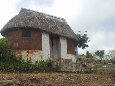
Palapas


Close up: needs some repair!


Chiapas: rainforest calls for wooden walls, screened in.


Constructing a palapa for an exposition in the Plaza Grande.


My favorite: with the Caribbean out the front door.


Hopelchén, Campeche State in the hills.


Ranch style, Yucatán State.


Sticks and stone wall, Yucatecan style.


The American Heritage Dictionary defines a palapa as "An open-sided dwelling with a thatched roof made of dried palm leaves or a structure, such as a bar or restaurant in a tropical resort that is open-sided and thatched with palm leaves. Perhaps from American Spanish, a kind of palm tree."

Wikipedia says the palapa is of Philippine origin and after it was brought to Mexico the people of the region loved them for their heat resistance and the fresh air that flows through. It goes on to say that the palapas were very similar to the indigenous architecture from "western cultures"; what does that mean? I only get Wikipedia in Spanish, so perhaps something was lost in translation.

The most interesting information I could find about the history of palapas was from a company called Wilson Laminate that sells palapas. It states: "some historians believe that palapas have over a 2000 year history in Mexico." What historians? I cannot seem to find any information in the few hours I have been searching the internet. I do believe the construction was used in Mexico for a long long time, and I can believe there was an influence by the Philipinos some time later.

Having lived in Hawaii and traveled through the South Pacific, I can safely say that as unique as the construction of hales, bures, bales, or whatever you want to call these palm-thatched huts can be, there is a similarity that leaves me a little confused. If this were some important link to the history of mankind, I would pursue it to see what the link is. I just happen to like palapas, and will may end up living in one some day...preferably one on the Caribbean coast somewhere. My house and the pool for a palapa en la playa!

Palapa dock near Livingston, Guatemala, Bahía de Amatique.